


Overview
The hike to Jocelyn Hill from Caleb Pike through the southern portion of Gowlland Tod Provincial Park offers many incredible views of Saanich Arm and the area looking west to the Malahat. The route climbs steeply, passing Holmes Peak, before following the Ridge Trail and eventually making a final, steep climb to the top.
The trail has several sections of inclines and declines as it passes over the rolling hills. There is one steep section near the end. Due to the exposed rock on some sections of the trail, it can be slippery during or after a rainfall, so use caution.
From the parking lot at Caleb Pike, pass the wooden map board and immediately go right, falling the trail down into the forest. Within minutes, you reach a junction. Go right at the sign and follow the meandering trail through the lush west coast forest. The trail begins to climb quickly as you find yourself having to stop to catch your breath.
The trail eventually exits the forest and passes underneath some power lines, where there is another sign and junction. Go left towards Holmes Peak and stay on the wide trail, continuing to pass under the power lines. The trail will climb steeply and then re-enter the forest. Just to the left of a grove of arbutus trees is an opening on a rocky outcrop. This is Holmes Peak and will give you your first scenic view of Saanich Arm on a clear, sunny day.
After enjoying the view, return to the trail and continue following it as it descends quickly and arrives at a junction. Going right will return you to the junction at the power lines, which might be the route you prefer to take upon your return. However, go left and continue following the Ridge Trail towards Jocelyn Hill. The trail is well defined and it gains and loses small amounts of elevation for the next section. Along the way, there are several openings with views looking west.
The trail reaches a junction with a sign saying that there is 1.8km to go to Jocelyn Hill. Go left and continue following the trail that is furthest to the west as it offers the best views. Not too much further along, you reach another sign which marks the start of Jocelyn Loop. Go left at this sign and continue following the trail to a third junction point. Again, go left and stay on the trail.
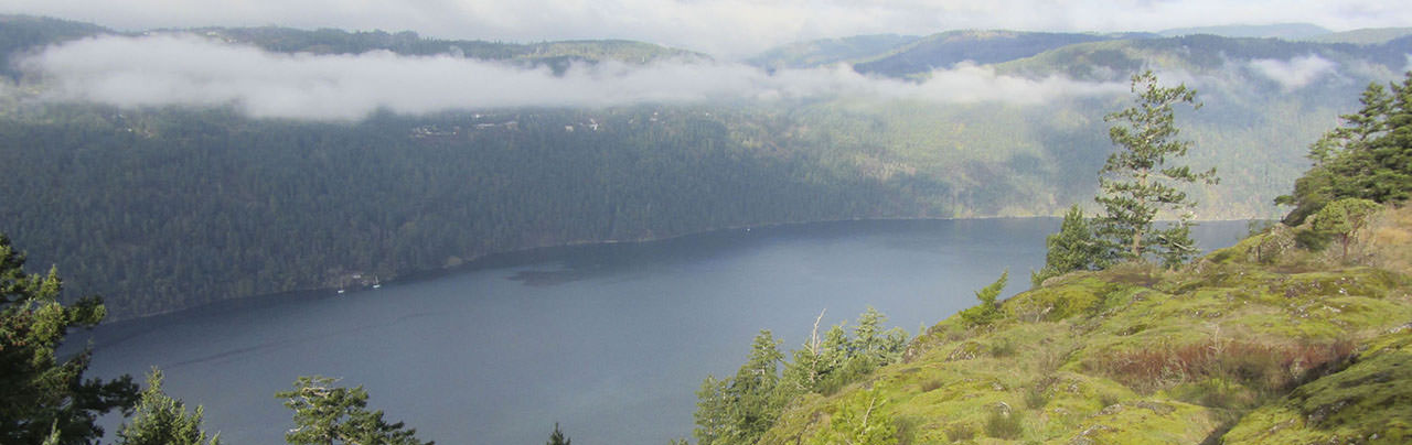
The trail climbs steeply, giving you an indication that you are almost there. The steep section goes up loose rock but offers some great views along the way as you stop to rest. Follow the trail as it begins to level and comes to a rocky opening that overlooks the Saanich Arm. This is the best view from Jocelyn Hill and the point where most people stop for lunch. Carefully step down on the rocks and pick a large rock to sit and enjoy the view.
The summit of Jocelyn Hill is not obvious as the trail wraps around it and then begins to descend on the other side. There are two options for returning, you can either go back the way you came or, continue along the trail and follow it as it descends to a junction. At the junction, go right and hike along the route known as Jocelyn Loop, which will return you to one of the signs you passed earlier. At that sign, you will go left and follow the same trail back to Caleb Pike that you took earlier.
Make sure you go right at the junctions near Jocelyn Hill as you follow the trail to Saanich Arm. As you hike back along the Ridge Trail, you can decide whether to hike back up to Holmes Peak or go left at the junction and bypass the uphill section, returning you directly to the trail under the power lines. After the power lines, follow the trail into the forest as it descends quickly until it reaches the final junction, where you go left and return to the parking lot at Caleb Pike.
Additional Notes
Jocelyn Hill can also be hiked from McKenzie Bight at the north end of Gowlland Tod Provincial Park. Or, if you are able to plan it so you can park a vehicle at both ends, you can do Jocelyn Hill as a through-hike taking you from one end to the other.
Driving Directions
The hike to Jocelyn Hill via Caleb Pike begins from the southern portion of Gowlland Tod Provincial Park. From downtown Victoria, follow Douglas Road northbound as it becomes Highway #1, The Trans-Canada Highway. Take Exit #14 (Langford / Highlands) and stay in the right lane, turning right onto Millstream Road towards Highlands. Follow Millstream Road past the busy shopping malls and continue on the single lane road as it winds its way through the Highlands neighbourhood for the next 6km or so. Watch for signs to Gowlland Tod Provincial Park and turn left onto Caleb Pike Road. Drive to the end of the road and park in the gravel parking lot.
Note: During the off season, the gravel parking lot is usually blocked off but you can park in the overflow parking lot up, to the left of Caleb Pike, then walk through the main gravel parking lot to the start of the trail.
Additional Information
Dog-Friendly
Dogs are permitted in Gowlland Tod Provincial Park but must be kept on a leash at all times. There is wildlife in the park, including several cougar sightings, so it is important to keep your dog leashed. Please ensure to pick up after your dog and remove all excrement from the park.
Toilets
Pit toilets are located near the gravel parking lot at Caleb Pike. There are no other toilets along the trail to Jocelyn Hill.
Although we try to keep information as current as possible, www.victoriatrails.com makes no warranty or representation as to the availability, quality, fitness for purpose, conditions or accuracy of the information provided with respect to this trail or trails. The information provided herein is further subject to our Terms of Use.

Comments
Be the first to submit your experience about this trail.
Add Comment